
Fire modelling research improves our understanding of how and when fire propagates across different landscapes under different weather conditions. This understanding enables better warnings and more informed community safety, and a more precise allocation of resources for response.
The aim of the Bushfire and Natural Hazards CRC research in this Fire Predictive Services theme was to bridge the gap between fire danger prediction systems based on the science of the 1950’s and 60’s and a modern system that draws on current research, technology and conditions.
CRC research has created a base of solid scientific evidence that builds on a long history of fire danger ratings research in Australia. This has provided tools for CRC partners that enhance the way the Australian landscape is monitored with (near) real time fire-spread modelling, which improves their ability to predict and respond to fire.
The work in this theme is closely aligned with the research in the Extreme Weather and Managing the Landscape themes. Together, these themes provide the ability to understand, predict, forecast and monitor bushfires, which are the fundamental elements needed to improve resilience through better planning, preparedness, risk management and response.
Online tools
These online tools were developed with CRC research and are designed to be ready for use. The tools here have been curated for this Driving Change theme. See more tools in the other themes.
AUSTRALIAN FLAMMABILITY MONITORING SYSTEM
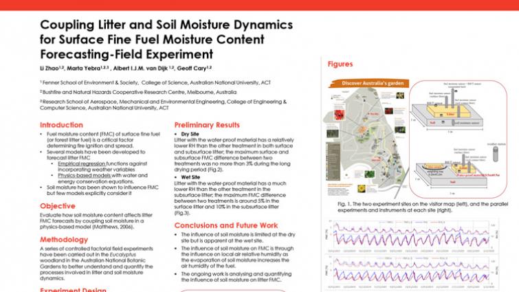
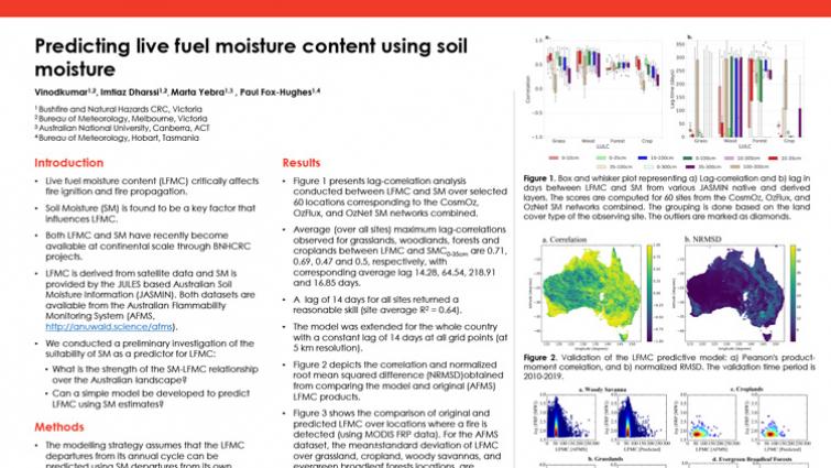
Effectively providing a clearer picture of immediate fire risks, the Australian Flammability Monitoring System uses satellite data to collect information on live moisture content in trees, shrubs, grass and soil. It then displays this information on an interactive map, which will help fire managers in their prescribed burning efforts and prepositioning of firefighting resources.
The first online mapping tool of its kind to be introduced in Australia, the prototype system uses satellite data to provide a clear picture of the landscape where there are high levels of vegetation and soil dryness, which are the perfect conditions for a severe bushfire.
The soil moisture data is derived from another CRC-funded prototype system called the JULES-based Australian Soil Moisture Information (JASMIN) system. The JASMIN system estimates soil moisture on four soil layers over the top 3 meters of soil, and takes into account the effect of different vegetation types, root depth, stomatal resistance and spatially varying soil texture. You can access the JASMIN system's raw data here.
SAVANNA MONITORING AND EVALUATION REPORTING FRAMEWORK
This online tool evaluates the effects of fire where burnt area mapping is available across the Northern Territory, large parts of Western Australia, and Northern Queensland. It assesses nearly twenty years of data to show where bushfires have burnt, at what time of year (early or late dry season) and when an area was last burnt.
PRESCRIBED BURNING ATLAS
The Prescribed Burning Atlas is a website designed specifically to assist and inform prescribed burning strategies so that land and fire managers can tailor their burning strategies to outcomes that will best reduce the risk in a target area within available budgets.
Developed through the Bushfire and Natural Hazards CRC in partnership with the University of Wollongong, University of Melbourne and Western Sydney University, the Prescribed Burning Atlas incorporates thousands of fire simulations to compare the level of risk reduction achieved from different combinations of prescribed burning techniques. The Atlas also compares the costs of different mitigation options and their effect on reducing the likelihood of life loss, property loss and landscape damage, as well as the effects of climate change on prescribed burning effectiveness.
It covers 13 different landscape types across New South Wales, ACT, Victoria, Tasmania, South Australia and Queensland, comprising different types of landscapes such as temperate forests, grasslands, savannas, deserts, woodlands and scrub.
Case studies
CRC research is driving change across communities, government and emergency service agencies, as highlighted by the case studies relevant to each Driving Change theme.
Highlights
This collection is a curation of the best and most recent news articles, Hazard Notes, videos, posters, guides, journal articles and reports relevant to this theme.
News

 at 7.30pm 30 December 2019. Photo courtesy Ms Janice Newnham.")


 and Neil Cooper (right) with their 2020 IAWF awards.")


 presenting Dr Marta Yebra (middle) with the 2019 Outstanding Achievement in Research Utilisation award for her research that she has done alongside lead end-user Dr Adam Leavesley (right).")


Resources


")


Publications


 Bright media 3.9µm threshold values per interim biogeographical regionalisation of Australia (IBRA) sub-region for a) early-summer and b) early-winter, demonstrating the spatial and seasonal variations in Bright threshold val")


")


 at 7.30pm 30 December 2019. Photo courtesy Ms Janice Newnham.")

")


 contributes to fire danger and behavior.")


Projects
This selection of user-driven projects allows you to explore the detail of the research. These projects, spanning the eight years of the CRC, are especially relevant to this theme, but may appear within other themes as well.


