The ability to understand, predict, forecast and monitor extreme weather is fundamental to understanding the threat posed to communities and, in turn, our ability to provide appropriate warnings in the lead up to extreme weather. The Bushfire and Natural Hazards CRC sought to improve the scientific understanding of extreme weather in Australia and inform the development of numerical weather prediction systems specifically for severe weather.
The outcomes of the projects within this Extreme Weather theme have strengthened our national capability to understand and forecast extreme weather events, particularly through the Coastal Erosion Story Map, the Extreme Sea Levels in Australia website, the Pyrcocumulonimbus Firepower Threshold and many other valuable resources.
Online tools
These online tools were developed with CRC research and are designed to be ready for use. The tools here have been curated for this Driving Change theme. See more tools in the other themes.
COASTAL EROSION STORY MAP
This Story Map sets out the key steps required to understand coastal erosion in situations where storm clusters are recognised as a possible driver.
The Map begins by providing some background to understanding the context of an eroding shoreline. It uses synthetic storm clusters to drive beach erosion and presents two case studies that model beach response to these synthetic clusters for current sea level conditions. Finally, the Map explores a method for evaluating impact of coastal erosion on infrastructure assets.
Scroll through interactive text, imagery and maps to learn more about understanding the cause, response and impact of coastal erosion.
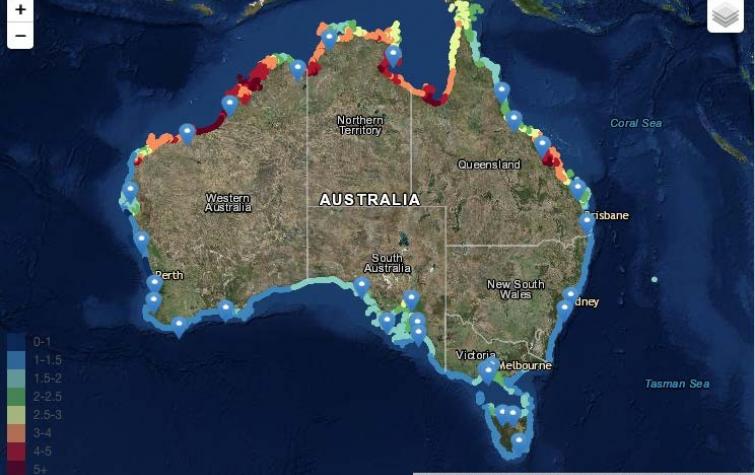
EXTREME SEA LEVELS IN AUSTRALIA
Extreme sea levels result from the combined effects of a range of factors including astronomical tides, long-term sea-level variability, storm surges due to pressure and wind, and wave breaking processes. In order to protect life and property, coastal planners and emergency managers require accurate estimates of flood risk.
Providing reliable predictions of extreme sea levels for this purpose represents a significant challenge due to the range of complex processes that vary from beach to beach, town to town, and state to state around the entire Australian continent.
Extreme value analysis has been applied to sea level data to predict Average Recurrence Intervals at ~1km spacing around the entire Australian coastline including islands. These statistics and relevant plots and time series data have been made available to the public via an interactive web tool, providing a consistent, accessible, up-to-date dataset for use by coastal planners and emergency managers.
PYROCUMULONIMBUS FIREPOWER THRESHOLD
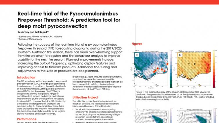
The Pyrocumulonimbus Firepower Threshold is diagnostic technology that measures the threshold or minimum firepower required for fire-generated thunderstorms to form, essentially assessing the atmospheric potential to support the development of a fire sufficiently large and intense for one of these storms to develop. It helps predict when these storms might occur, so that fire agencies can warn communities and firefighters.
The Pyrocumulonimbus Firepower Threshold is used internally at weather forecasting services, such as the Bureau of Meteorology, as well as fire agencies across the country. For more information about this tool, visit the research project page.
Case studies
CRC research is driving change across communities, government and emergency service agencies, as highlighted by the case studies relevant to each Driving Change theme.
Highlights
This collection is a curation of the best and most recent news articles, Hazard Notes, videos, posters, guides, journal articles and reports relevant to this theme.
News


Resources


: a tool for pyrocumulonimbus prediction by Kevin Tory")


Publications


 during the afternoon of the most active moist pyro-convective day of the 2019/2020 season, 30 December 2019. The corresponding PFT flag forecast (right) shows the potential threat was well forecast. The fire locations are i")
 applied to an F-160 thermodynamic diagram, with quantities required for the PFT calculation overlaid")


Projects
This selection of user-driven projects allows you to explore the detail of the research. These projects, spanning the eight years of the CRC, are especially relevant to this theme, but may appear within other themes as well.
")